| |||||||||||||||||||||||||||||||||||||||||||


| |||||||||||||||||||||||||||||||||||||||||||
Joan Ferrini-Mundy to Become NSF Assistant Director for Education and Human Resources
Fri, 25 Feb 2011 13:51:00 -0600

Joan Ferrini-Mundy has been selected as the new assistant director of the National Science Foundation's (NSF) Directorate for Education and Human Resources (EHR). She has held the position on an acting basis for the last year.
EHR is the part of NSF that funds the majority of research and development in science education, including preparation of mathematics and science teachers, development of curriculum materials and educational technologies and research into the most effective ...
This is an NSF News item.
This e-mail update was generated automatically based on your subscription to the category listed above. Some updates may belong to more than one category, resulting in duplicate messages.
 | Subscriber Services: Manage Preferences | Unsubscribe | Help | Contact NSF | |
| Follow NSF: | | |
GovDelivery, Inc. sending on behalf of the National Science Foundation · 4201 Wilson Boulevard · Arlington, VA 22230 · 703-292-5111 |
SPC Severe Thunderstorm Watch 19 Status Reports
Fri, 25 Feb 2011 14:11:03 -0600
STATUS REPORT ON WW 19 SEVERE WEATHER THREAT CONTINUES RIGHT OF A LINE FROM 10 ESE NHK TO 15 E PHL. ..SPC..02/25/11 ATTN...WFO...LWX...PHI... STATUS REPORT FOR WS 19 SEVERE WEATHER THREAT CONTINUES FOR THE FOLLOWING AREAS DEC001-005-252140- DE . DELAWARE COUNTIES INCLUDED ARE KENT SUSSEX MDC011-252140- MD . MARYLAND COUNTIES INCLUDED ARE CAROLINE NJC001-005-009-011-015-033-252140- NJ . NEW JERSEY COUNTIES INCLUDED ARE ATLANTIC BURLINGTON CAPE MAY CUMBERLAND GLOUCESTER SALEMRead more
To change your subscriptions or preferences or stop subscriptions anytime, log in to your User Profile with your e-mail address. For questions or problems with the service, contact support@govdelivery.com.
This service is provided by NOAA’s National Weather Service.

GovDelivery, Inc. (800-439-1420) sending on behalf of NOAA's National Weather Service · 1325 East West Highway · Silver Spring, MD 20910
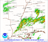
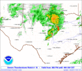
SPC Severe Thunderstorm Watch 19
Fri, 25 Feb 2011 11:22:02 -0600
URGENT - IMMEDIATE BROADCAST REQUESTED SEVERE THUNDERSTORM WATCH NUMBER 19 NWS STORM PREDICTION CENTER NORMAN OK 1220 PM EST FRI FEB 25 2011 THE NWS STORM PREDICTION CENTER HAS ISSUED A SEVERE THUNDERSTORM WATCH FOR PORTIONS OF DISTRICT OF COLUMBIA DELAWARE THE EASTERN SHORE OF MARYLAND SOUTHERN NEW JERSEY EXTREME SOUTHEAST PENNSYLVANIA NORTHEAST VIRGINIA COASTAL WATERS EFFECTIVE THIS FRIDAY AFTERNOON FROM 1220 PM UNTIL 400 PM EST. HAIL TO 0.5 INCH IN DIAMETER...THUNDERSTORM WIND GUSTS TO 70 MPH...AND DANGEROUS LIGHTNING ARE POSSIBLE IN THESE AREAS. THE SEVERE THUNDERSTORM WATCH AREA IS APPROXIMATELY ALONG AND 65 STATUTE MILES EAST AND WEST OF A LINE FROM PHILADELPHIA PENNSYLVANIA TO 5 MILES WEST SOUTHWEST OF PATUXENT RIVER MARYLAND. FOR A COMPLETE DEPICTION OF THE WATCH SEE THE ASSOCIATED WATCH OUTLINE UPDATE (WOUS64 KWNS WOU9). REMEMBER...A SEVERE THUNDERSTORM WATCH MEANS CONDITIONS ARE FAVORABLE FOR SEVERE THUNDERSTORMS IN AND CLOSE TO THE WATCH AREA. PERSONS IN THESE AREAS SHOULD BE ON THE LOOKOUT FOR THREATENING WEATHER CONDITIONS AND LISTEN FOR LATER STATEMENTS AND POSSIBLE WARNINGS. SEVERE THUNDERSTORMS CAN AND OCCASIONALLY DO PRODUCE TORNADOES. DISCUSSION...LOW-TOPPED CONVECTION IS GRADUALLY INCREASING WITHIN THE MIDLEVEL DRY SLOT...JUST IN ADVANCE OF AN EJECTING MIDLEVEL TROUGH AND A SURFACE COLD FRONT. SURFACE HEATING IN THE DRY SLOT AND RESIDUAL BOUNDARY LAYER DEWPOINTS IN THE MID 50S WILL SUPPORT SBCAPE NEAR 500 J/KG...WHILE STRONG WINDS JUST ABOVE THE SURFACE WILL FAVOR MOMENTUM TRANSFER TO THE GROUND AND DAMAGING WIND POTENTIAL WITH THE STRONGER LINE SEGMENTS/CELLS. ADDITIONALLY...THE STRONG LOW-LEVEL SHEAR COULD SUPPORT ROTATING STORMS...AND AN ISOLATED TORNADO CANNOT BE RULED OUT THIS AFTERNOON. AVIATION...A FEW SEVERE THUNDERSTORMS WITH HAIL SURFACE AND ALOFT TO 0.5 INCH. EXTREME TURBULENCE AND SURFACE WIND GUSTS TO 60 KNOTS. A FEW CUMULONIMBI WITH MAXIMUM TOPS TO 300. MEAN STORM MOTION VECTOR 27045. ...THOMPSONRead more
SPC Severe Thunderstorm Watch 19 Status Reports
Fri, 25 Feb 2011 11:22:11 -0600
STATUS FOR WATCH 0019 HAS NOT BEEN ISSUED YETRead more
To change your subscriptions or preferences or stop subscriptions anytime, log in to your User Profile with your e-mail address. For questions or problems with the service, contact support@govdelivery.com.
This service is provided by NOAA’s National Weather Service.
GovDelivery, Inc. (800-439-1420) sending on behalf of NOAA's National Weather Service · 1325 East West Highway · Silver Spring, MD 20910
| |||||||||||||||||||||||||||||||||||||||||||
SPC - No watches are valid as of Fri Feb 25 10:02:05 UTC 2011
Fri, 25 Feb 2011 04:01:10 -0600
No watches are valid as of Fri Feb 25 10:02:05 UTC 2011.
To change your subscriptions or preferences or stop subscriptions anytime, log in to your User Profile with your e-mail address. For questions or problems with the service, contact support@govdelivery.com.
This service is provided by NOAA’s National Weather Service.
GovDelivery, Inc. (800-439-1420) sending on behalf of NOAA's National Weather Service · 1325 East West Highway · Silver Spring, MD 20910
SPC Severe Thunderstorm Watch 18 Status Reports
Fri, 25 Feb 2011 01:41:03 -0600
STATUS REPORT ON WW 18 SEVERE WEATHER THREAT CONTINUES RIGHT OF A LINE FROM 10 SSE ANB TO 30 S RMG TO 25 WSW TYS TO 35 NE TYS TO 35 SE JKL TO 50 ESE JKL. FOR ADDITIONAL INFORMATION SEE MESOSCALE DISCUSSION 0137. ..PETERS..02/25/11 ATTN...WFO...FFC...JKL...MRX... STATUS REPORT FOR WS 18 SEVERE WEATHER THREAT CONTINUES FOR THE FOLLOWING AREAS GAC015-045-057-063-067-077-085-089-097-111-113-117-121-123-129- 135-139-143-149-187-213-223-227-233-281-291-311-250840- GA . GEORGIA COUNTIES INCLUDED ARE BARTOW CARROLL CHEROKEE CLAYTON COBB COWETA DAWSON DEKALB DOUGLAS FANNIN FAYETTE FORSYTH FULTON GILMER GORDON GWINNETT HALL HARALSON HEARD LUMPKIN MURRAY PAULDING PICKENS POLK TOWNS UNION WHITE KYC095-133-250840- KY . KENTUCKY COUNTIES INCLUDED ARE HARLAN LETCHERRead more
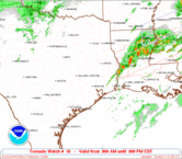
SPC Tornado Watch 17 Status Reports
Fri, 25 Feb 2011 00:35:03 -0600
STATUS REPORT ON WW 17 SEVERE WEATHER THREAT CONTINUES RIGHT OF A LINE FROM 35 E MEI TO 25 E TCL TO 25 WNW CHA. ..COHEN..02/25/11 ATTN...WFO...BMX...HUN...JAN...MEG... STATUS REPORT FOR WT 17 SEVERE WEATHER THREAT CONTINUES FOR THE FOLLOWING AREAS ALC007-015-019-027-029-049-055-065-071-073-111-115-117-119-121- 250740- AL . ALABAMA COUNTIES INCLUDED ARE BIBB CALHOUN CHEROKEE CLAY CLEBURNE DEKALB ETOWAH HALE JACKSON JEFFERSON RANDOLPH ST. CLAIR SHELBY SUMTER TALLADEGA THE WATCH STATUS MESSAGE IS FOR GUIDANCE PURPOSES ONLY. PLEASE REFER TO WATCH COUNTY NOTIFICATION STATEMENTS FOR OFFICIAL INFORMATION ON COUNTIES...INDEPENDENT CITIES AND MARINE ZONES CLEARED FROM SEVERE THUNDERSTORM AND TORNADO WATCHES.Read more
SPC Tornado Watch 16 Status Reports
Fri, 25 Feb 2011 00:33:04 -0600
STATUS REPORT ON WW 16 SEVERE WEATHER THREAT CONTINUES RIGHT OF A LINE FROM 45 NE HSV TO 15 WSW CSV TO 50 SW LOZ. WW 16 WILL BE ALLOWED TO EXPIRE AT 250700Z. ..COHEN..02/25/11 ATTN...WFO...LMK...OHX... STATUS REPORT FOR WT 16 SEVERE WEATHER THREAT CONTINUES FOR THE FOLLOWING AREAS TNC035-061-175-250700- TN . TENNESSEE COUNTIES INCLUDED ARE CUMBERLAND GRUNDY VAN BUREN THE WATCH STATUS MESSAGE IS FOR GUIDANCE PURPOSES ONLY. PLEASE REFER TO WATCH COUNTY NOTIFICATION STATEMENTS FOR OFFICIAL INFORMATION ON COUNTIES...INDEPENDENT CITIES AND MARINE ZONES CLEARED FROM SEVERE THUNDERSTORM AND TORNADO WATCHES.Read more
SPC Tornado Watch 15 Status Reports
Thu, 24 Feb 2011 21:44:04 -0600
STATUS REPORT ON WW 15 SEVERE WEATHER THREAT CONTINUES RIGHT OF A LINE FROM 5 ENE CKV TO 35 NE HOP TO 30 NW BWG. WW 15 WILL BE ALLOWED TO EXPIRE AT 250400Z. ..COHEN..02/25/11 ATTN...WFO...PAH...LMK... STATUS REPORT FOR WT 15 SEVERE WEATHER THREAT CONTINUES FOR THE FOLLOWING AREAS KYC177-219-250400- KY . KENTUCKY COUNTIES INCLUDED ARE MUHLENBERG TODD THE WATCH STATUS MESSAGE IS FOR GUIDANCE PURPOSES ONLY. PLEASE REFER TO WATCH COUNTY NOTIFICATION STATEMENTS FOR OFFICIAL INFORMATION ON COUNTIES...INDEPENDENT CITIES AND MARINE ZONES CLEARED FROM SEVERE THUNDERSTORM AND TORNADO WATCHES.Read more
SPC Tornado Watch 14 Status Reports
Thu, 24 Feb 2011 21:40:05 -0600
STATUS REPORT ON WW 14 SEVERE WEATHER THREAT CONTINUES RIGHT OF A LINE FROM 30 NNW JAN TO 25 SE GWO TO 40 N TUP TO 20 S CKV. ..COHEN..02/25/11 ATTN...WFO...LZK...JAN...MEG...OHX... STATUS REPORT FOR WT 14 SEVERE WEATHER THREAT CONTINUES FOR THE FOLLOWING AREAS MSC003-017-081-115-117-145-250440- MS . MISSISSIPPI COUNTIES INCLUDED ARE ALCORN CHICKASAW LEE PONTOTOC PRENTISS UNION TNC071-250440- TN . TENNESSEE COUNTIES INCLUDED ARE HARDIN THE WATCH STATUS MESSAGE IS FOR GUIDANCE PURPOSES ONLY. PLEASE REFER TO WATCH COUNTY NOTIFICATION STATEMENTS FOR OFFICIAL INFORMATION ON COUNTIES...INDEPENDENT CITIES AND MARINE ZONES CLEARED FROM SEVERE THUNDERSTORM AND TORNADO WATCHES.Read more
To change your subscriptions or preferences or stop subscriptions anytime, log in to your User Profile with your e-mail address. For questions or problems with the service, contact support@govdelivery.com.
This service is provided by NOAA’s National Weather Service.
GovDelivery, Inc. (800-439-1420) sending on behalf of NOAA's National Weather Service · 1325 East West Highway · Silver Spring, MD 20910
SPC Severe Thunderstorm Watch 18 Status Reports
Fri, 25 Feb 2011 00:37:03 -0600
STATUS REPORT ON WW 18 SEVERE WEATHER THREAT CONTINUES RIGHT OF A LINE FROM 25 SW CSV TO 15 NE CSV TO 20 SW LOZ TO 30 WNW JKL. ..COHEN..02/25/11 ATTN...WFO...FFC...JKL...MRX... STATUS REPORT FOR WS 18 SEVERE WEATHER THREAT CONTINUES FOR THE FOLLOWING AREAS GAC015-045-047-055-057-063-067-077-083-085-089-097-111-113-115- 117-121-123-129-135-139-143-149-187-213-223-227-233-281-291-295- 311-313-250740- GA . GEORGIA COUNTIES INCLUDED ARE BARTOW CARROLL CATOOSA CHATTOOGA CHEROKEE CLAYTON COBB COWETA DADE DAWSON DEKALB DOUGLAS FANNIN FAYETTE FLOYD FORSYTH FULTON GILMER GORDON GWINNETT HALL HARALSON HEARD LUMPKIN MURRAY PAULDING PICKENS POLK TOWNS UNION WALKER WHITE WHITFIELD KYC013-025-051-095-109-119-121-125-129-131-133-189-193-235- 250740- KY . KENTUCKY COUNTIES INCLUDED ARERead more
SPC Tornado Watch 17 Status Reports
Fri, 25 Feb 2011 00:35:03 -0600
STATUS REPORT ON WW 17 SEVERE WEATHER THREAT CONTINUES RIGHT OF A LINE FROM 35 E MEI TO 25 E TCL TO 25 WNW CHA. ..COHEN..02/25/11 ATTN...WFO...BMX...HUN...JAN...MEG... STATUS REPORT FOR WT 17 SEVERE WEATHER THREAT CONTINUES FOR THE FOLLOWING AREAS ALC007-015-019-027-029-049-055-065-071-073-111-115-117-119-121- 250740- AL . ALABAMA COUNTIES INCLUDED ARE BIBB CALHOUN CHEROKEE CLAY CLEBURNE DEKALB ETOWAH HALE JACKSON JEFFERSON RANDOLPH ST. CLAIR SHELBY SUMTER TALLADEGA THE WATCH STATUS MESSAGE IS FOR GUIDANCE PURPOSES ONLY. PLEASE REFER TO WATCH COUNTY NOTIFICATION STATEMENTS FOR OFFICIAL INFORMATION ON COUNTIES...INDEPENDENT CITIES AND MARINE ZONES CLEARED FROM SEVERE THUNDERSTORM AND TORNADO WATCHES.Read more
SPC Tornado Watch 16 Status Reports
Fri, 25 Feb 2011 00:33:04 -0600
STATUS REPORT ON WW 16 SEVERE WEATHER THREAT CONTINUES RIGHT OF A LINE FROM 45 NE HSV TO 15 WSW CSV TO 50 SW LOZ. WW 16 WILL BE ALLOWED TO EXPIRE AT 250700Z. ..COHEN..02/25/11 ATTN...WFO...LMK...OHX... STATUS REPORT FOR WT 16 SEVERE WEATHER THREAT CONTINUES FOR THE FOLLOWING AREAS TNC035-061-175-250700- TN . TENNESSEE COUNTIES INCLUDED ARE CUMBERLAND GRUNDY VAN BUREN THE WATCH STATUS MESSAGE IS FOR GUIDANCE PURPOSES ONLY. PLEASE REFER TO WATCH COUNTY NOTIFICATION STATEMENTS FOR OFFICIAL INFORMATION ON COUNTIES...INDEPENDENT CITIES AND MARINE ZONES CLEARED FROM SEVERE THUNDERSTORM AND TORNADO WATCHES.Read more
SPC Tornado Watch 15 Status Reports
Thu, 24 Feb 2011 21:44:04 -0600
STATUS REPORT ON WW 15 SEVERE WEATHER THREAT CONTINUES RIGHT OF A LINE FROM 5 ENE CKV TO 35 NE HOP TO 30 NW BWG. WW 15 WILL BE ALLOWED TO EXPIRE AT 250400Z. ..COHEN..02/25/11 ATTN...WFO...PAH...LMK... STATUS REPORT FOR WT 15 SEVERE WEATHER THREAT CONTINUES FOR THE FOLLOWING AREAS KYC177-219-250400- KY . KENTUCKY COUNTIES INCLUDED ARE MUHLENBERG TODD THE WATCH STATUS MESSAGE IS FOR GUIDANCE PURPOSES ONLY. PLEASE REFER TO WATCH COUNTY NOTIFICATION STATEMENTS FOR OFFICIAL INFORMATION ON COUNTIES...INDEPENDENT CITIES AND MARINE ZONES CLEARED FROM SEVERE THUNDERSTORM AND TORNADO WATCHES.Read more
SPC Tornado Watch 14 Status Reports
Thu, 24 Feb 2011 21:40:05 -0600
STATUS REPORT ON WW 14 SEVERE WEATHER THREAT CONTINUES RIGHT OF A LINE FROM 30 NNW JAN TO 25 SE GWO TO 40 N TUP TO 20 S CKV. ..COHEN..02/25/11 ATTN...WFO...LZK...JAN...MEG...OHX... STATUS REPORT FOR WT 14 SEVERE WEATHER THREAT CONTINUES FOR THE FOLLOWING AREAS MSC003-017-081-115-117-145-250440- MS . MISSISSIPPI COUNTIES INCLUDED ARE ALCORN CHICKASAW LEE PONTOTOC PRENTISS UNION TNC071-250440- TN . TENNESSEE COUNTIES INCLUDED ARE HARDIN THE WATCH STATUS MESSAGE IS FOR GUIDANCE PURPOSES ONLY. PLEASE REFER TO WATCH COUNTY NOTIFICATION STATEMENTS FOR OFFICIAL INFORMATION ON COUNTIES...INDEPENDENT CITIES AND MARINE ZONES CLEARED FROM SEVERE THUNDERSTORM AND TORNADO WATCHES.Read more
To change your subscriptions or preferences or stop subscriptions anytime, log in to your User Profile with your e-mail address. For questions or problems with the service, contact support@govdelivery.com.
This service is provided by NOAA’s National Weather Service.
GovDelivery, Inc. (800-439-1420) sending on behalf of NOAA's National Weather Service · 1325 East West Highway · Silver Spring, MD 20910

